Building the Earth Intelligence tool with Vibe Coding
March 13, 2026
How AI-powered development opened a new avenue in technology and enabled the creation of a comprehensive real-time geospatial platform using only open source data
In the rapidly evolving landscape of technology development, a new paradigm has emerged that’s revolutionizing how we build complex applications: Vibe Coding. This article explores how this innovative approach enabled the creation of SkyView Pro, a comprehensive Earth Intelligence Platform that integrates real-time satellite imagery, weather data, ocean currents, aircraft tracking, and live environmental monitoring — all powered entirely by open source data.
I originally built it to check weather patterns while traveling and to assess safe drone-flying conditions.
The Beauty of Ocean Dynamics
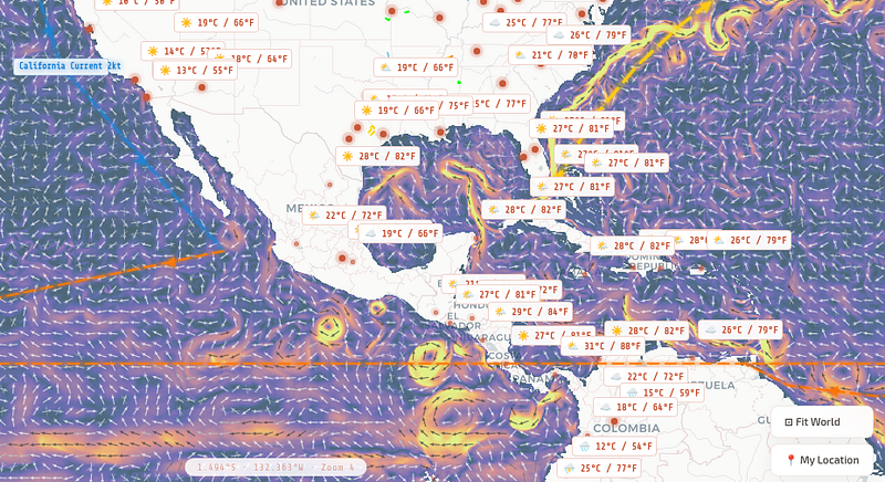
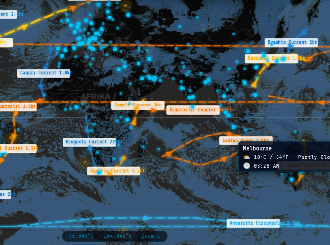
One of my favorite features is the ocean vortex visualization. Satellite altimetry data reveals these massive swirling structures that stretch across the ocean like fingerprints — each one unique and constantly changing.
🌊 Witnessing Nature’s Fluid Dynamics in Real-Time
Ocean currents create massive vortices that can stretch hundreds of kilometers across. These aren’t just beautiful — they’re vital to understanding:
- Heat distribution — How warm water from the tropics travels to polar regions
- Nutrient transport — Carrying the building blocks of marine ecosystems
- Weather patterns — Influencing atmospheric conditions thousands of miles away
- Climate systems — Regulating global temperatures through conveyor belt circulation
When you see these vortices animating in real-time on SkyView Pro, you’re watching the Earth’s circulatory system in action. The swirling patterns of the Gulf Stream, the Kuroshio Current, and the Antarctic Circumpolar Current become visible artworks of nature — mathematical perfection expressed through fluid dynamics.
These vortices aren’t static — they pulse, merge, and dissipate with the rhythm of the tides and seasons. Satellite altimetry data, freely available through open source initiatives, allows us to track these movements with incredible precision. The result is a living, breathing visualization of our planet’s most powerful fluid system.
🌍 100% Open Source Data
SkyView Pro is built entirely on freely available, open source geospatial data. No proprietary licenses, no expensive API subscriptions — just the power of publicly funded Earth observation programs and community-driven data collection.
Key Features
🛰️ Satellite Imagery
Real-time Sentinel-2 data with Copernicus integration — cloudless basemaps and live feeds from ESA.
🌊 Ocean Currents
19 major currents animated in real-time — Gulf Stream, Kuroshio, Antarctic Circumpolar, and more.
💨 Wind Particles
Canvas-based visualization with 600+ particles, color-coded by speed, direction, or altitude.
✈️ Aircraft Tracking
Real-time flight tracking with 150+ aircraft types. Smart landing notifications via WhatsApp and Home Assistant.
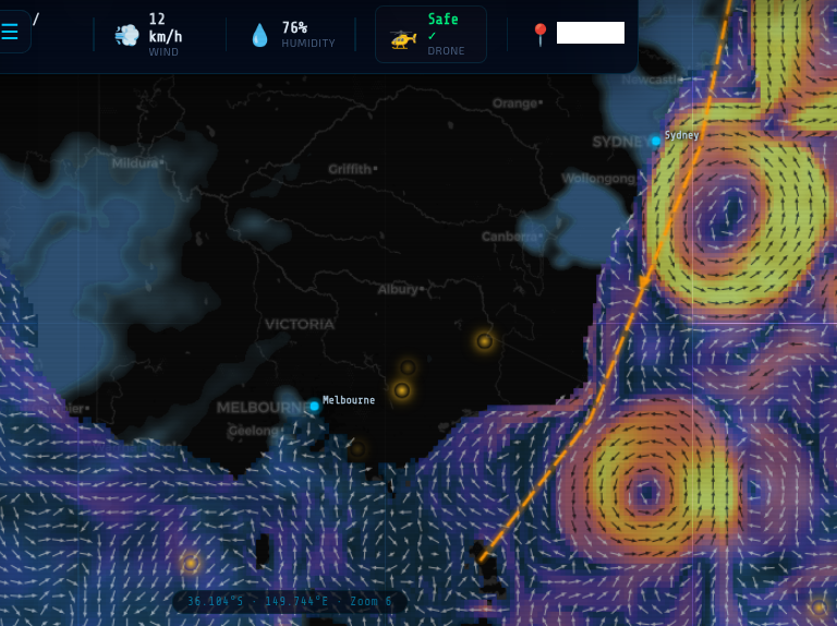
🚁 Drone Flyability Assistant
Smart drone flight safety monitoring that analyzes real-time weather conditions and alerts you when it’s safe to fly. The system tracks wind speed, gusts, precipitation, and visibility to provide instant flyability assessments — showing 🟢 Safe, 🟡 Caution, or 🔴 No Fly status based on current conditions. No more guessing if conditions are right for your drone flight.
🌤️ Weather
Live conditions and forecasts for 120+ cities.
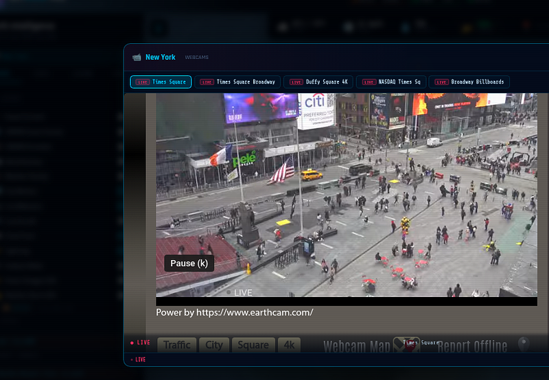
📹 Live Webcams
Public webcam feeds from major cities.
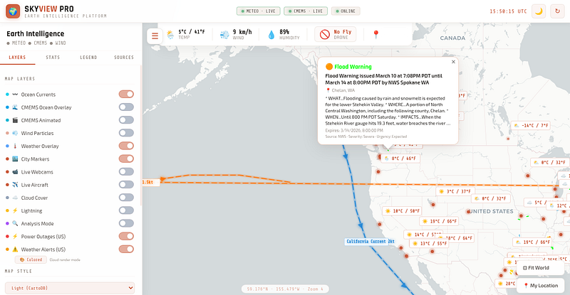
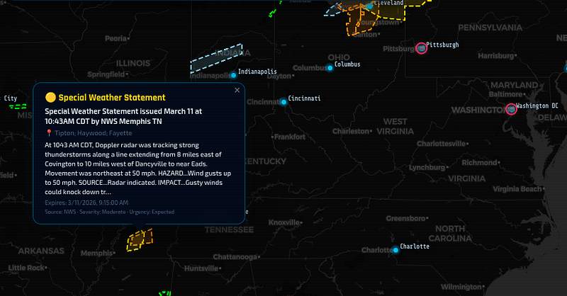
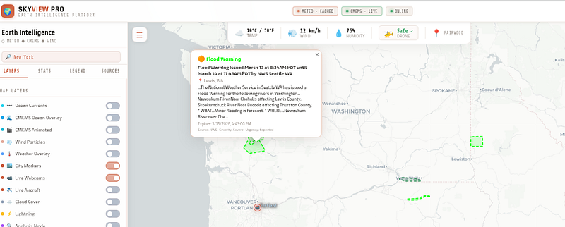
⚠️ Weather Alerts
NWS alerts for tornadoes, hurricanes, flash floods.
Screenshots Gallery
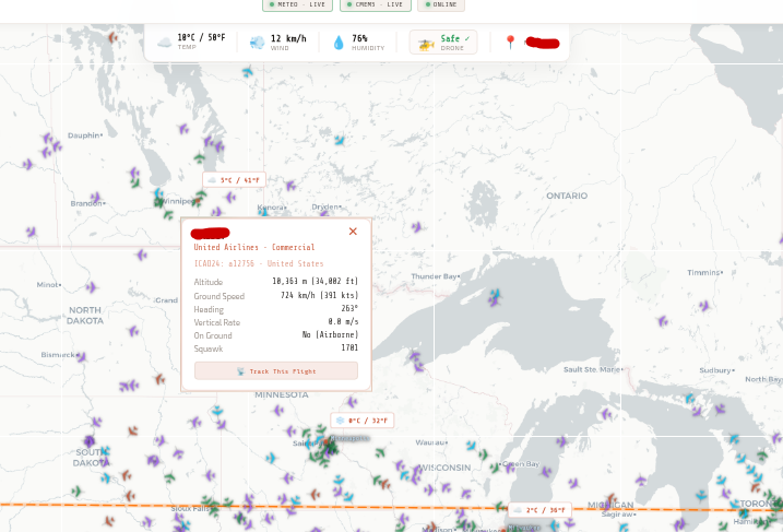


🚁 Know Exactly When to Fly Your Drone
Never wonder if conditions are right again. SkyView Pro’s Drone Flyability Assistant takes the guesswork out of drone flight planning. Instead of checking multiple weather apps and trying to calculate if it’s safe to fly, the platform analyzes current conditions for you and provides an instant go/no-go recommendation.
Safety Thresholds
- 🟢 Safe to Fly — Wind speeds under 20 km/h, clear visibility, no precipitation
- 🟡 Caution Advised — Wind speeds 20–30 km/h or moderate gusts
- 🔴 No Fly — Wind exceeding 30 km/h, rain, fog, or other unsafe conditions
What It Monitors
The system continuously tracks:
- Wind Speed & Gusts — Real-time wind velocity and sudden gusts that could destabilize your drone
- Precipitation — Rain, snow, or hail that could damage electronics
- Visibility — Fog, haze, or low clouds that could obstruct your view
- Temperature — Extreme heat or cold that could affect battery performance
📱 Smart Flight Notifications
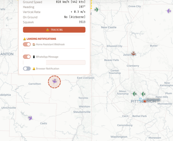
SkyView Pro’s intelligent tracking system monitors flights in real-time and automatically sends notifications the moment an aircraft touches down. Integration with WhatsApp and Home Assistant means you’ll receive instant alerts wherever you are — whether it’s a family member’s flight arriving safely or a business jet reaching its destination.
“AI Vibe Coding represents more than just a productivity boost — it’s a fundamental shift in what’s possible for individual engineers (even with no coding expertise) and small teams. Projects that once required entire engineering departments can now be built by passionate developers with AI assistance.”
Conclusion
SkyView Pro stands as a testament to what’s achievable when human creativity meets AI capability and open source data. By leveraging AI Vibe Coding and freely available geospatial data, I didn’t just build another mapping application — I created a comprehensive Earth Intelligence Platform that visualizes the beautiful complexity of our planet in real-time.
From ocean vortices to wind patterns, SkyView Pro makes the invisible visible. Raw open data, transformed into something you can see and understand.
As AI continues to evolve and open data initiatives expand, the possibilities for engineers — mechanical, civil, and beyond — will only grow. The question is no longer “Can we build this?” but rather “What will we discover next?”