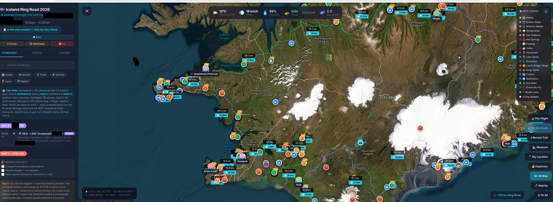
A ten-day drive around Iceland asks a lot of a phone: an itinerary, a map, a budget, a packing list, drone rules, fuel planning and emergency numbers, all in a country where the signal disappears for hours at a time. Every existing app handled one slice of that and assumed a connection. So I asked an LLM to build Iceland Ring Road 2026, a single self-contained web page that became the operating system of the trip and, wrapped as a signed Android app, lived on my home screen.
It held the whole journey: 76 timed stops, 405 hand-picked places across 20 map layers, maps that worked offline, live weather, wind, aurora and fuel prices, a GPS trail recorder, an expense tracker, and a drone safety system with 32 no-fly zones and a one-tap pre-flight check. This is the story of how it was built, and what it was like to depend on it for ten days.
01 / The premiseAn app for one trip
The plan already existed, scattered in the usual places: a spreadsheet itinerary, a folder of hotel screenshots, activity confirmations and a browser full of tabs on Icelandic drone law. The usual answer is a travel folder and a little hope: map lists that fail beyond the last phone mast, booking PDFs scrolled through at a fuel pump, a budget in a notes app and drone rules half remembered.
Iceland punishes that approach. Outside the south-west, coverage vanishes for long stretches, and some legs of the ring road run more than 200 kilometres between reliable pumps. I wanted the logistics to disappear. An app that already knows tonight’s hotel, the nearest restroom, whether the drone may legally fly here and how much has been spent so far is the difference between managing a trip and actually taking one.
The catch has always been cost. Nobody writes a polished app for a single ten-day holiday. Or rather, nobody used to.
02 / The processBuilt by conversation
I built it the way I have built my recent projects: by describing what I wanted to an LLM coding agent and refining the result. What came back was a single web page, about 6,000 lines and 350 KB, that opens straight from the phone with no server behind it, with the itinerary, the places, the drone zones, the daily driving plan and the warnings all inside.
The instructive part was what the model could not do. The code was the easy half. The data was the half that lasted, and it needed a human. I checked every hotel pin against the real booking confirmations, verified the drone rules against Icelandic and European authorities, and took the driving plan from my own spreadsheet rather than the model’s guesses. After that the loop was simple: describe a feature, reload, correct. When the web app was finished, the same conversation produced the Android project, the signing key and the release build, and the app settled onto my home screen beside ones made by real companies.
03 / ItineraryThe map and the plan
The heart of the app is the timeline: 76 stops across ten days, each with its location, cost and notes, in a scrolling feed beside the map. Tap any stop and the map flies to it. Each day has its own audit of distance and driving time with plain-language warnings about fuel gaps, weather and road etiquette, every place is one tap from the phone’s navigation apps, and the road conditions, travel-safety and emergency numbers are always a tap away. The model even added the flourishes a personal project rarely gets, including a “fly the route” mode that sweeps the camera cinematically along all ten days.
04 / The placesWhere you actually need to go
The itinerary covers where we meant to be. The 405 other places cover where we actually needed to go: groceries, fuel, restrooms, parking, restaurants and cafés, hot springs, lava viewpoints and volcanoes, across twenty layers that switch on and off, every one chosen for this route rather than scraped from a generic list.
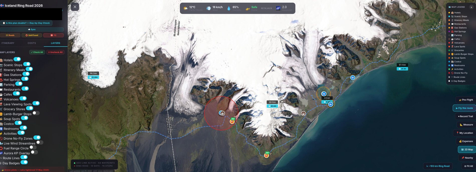
Fuel received special care, because range anxiety on this road is real. One layer shows how far a full tank of the rental car will go, the long gaps between pumps are flagged in each day’s warnings, and fuel-station pop-ups show live pump prices converted into home currency, with sensible fallbacks when offline.
05 / AirspaceDrone safety, built in
Iceland’s drone rules have tightened in recent years, and much of the route lies under overlapping restrictions: airports, national-park closures, site-specific bans and seasonal protection for nesting birds. Memory was not good enough. The app draws 32 no-fly zones on the map, each graded by severity with its rules in plain words, warns when the phone’s location approaches one, and offers a one-tap pre-flight check that compares the current weather with the drone’s limits and returns a verdict rather than a page of numbers.
A disclaimer built into the app itself
The zone list is a researched snapshot, not an official source. In a country where an eruption can redraw the airspace overnight, the app is the first check, never the last.
06 / ConnectivityBuilt for dead zones
One rule was non-negotiable: everything had to survive a dead zone, and live data was a bonus on top. Every place and every rule lives inside the app, and the map stores the tiles it has shown; a single button downloads the whole route corridor before departure. In ten days of driving through gaps in coverage, the map never once failed to appear.
When a signal was available, the app added live weather, wind, aurora forecasts and fuel prices, along with an animated wind layer that drifts across the map, the single most useful piece of weather in Iceland. A GPS trail recorder, an expense tracker with a budget, a daily packing list and syncing between devices completed the kit.
07 / ShippingInto the pocket
A trip app belongs on the phone, and turning the web page into an Android app was the least dramatic part of the project. The page was wrapped with Capacitor, signed, and installed like any other app, complete with its own icon, splash screen and themed status bar; the same page can also be installed straight from a browser. The model even kept itself honest, insisting that the browser version and the Android version stay identical so that there was only ever one source of truth.
08 / In the fieldThe trip in photos
It worked. Ten days around Route 1, and a few frames from the trip the app shepherded:










09 / RetrospectiveLooking back
Four features earned their keep. The offline maps were used constantly in the coverage gaps. The restroom and grocery layers, unglamorous as they are, were consulted every day. The one-tap navigation links handed each stop straight to the phone’s maps. And the drone warnings flagged restricted sites before we reached the trailhead.
There were lessons too. The drone list is a snapshot of fast-moving rules, and the app says so. A stale fuel price looks just like a live one unless you check its timestamp. Recording a GPS trail drains the battery on days when the phone is also the camera. And an app made for one person has no update channel; any fix meant my laptop and a fresh install. This is a demonstration of what LLM-assisted personal software can do, not a product, and its data is a hand-checked set for one route on one set of dates.
10 / TakeawayThe bigger picture
There has always been a kind of software that was possible in theory and absurd in practice: an application for an audience of one, with a shelf life of ten days. The economics never worked. Now they amount to an afternoon of conversation and a build, and the only scarce ingredient is knowing what you want.
The surprise is that the code turned out to be the disposable part. What mattered was the curated data: which restroom is free, which fuel gap is real, which waterfall can no longer be filmed from the air. An LLM can draft that list in seconds; it took a human with booking confirmations and regulation documents to make it trustworthy. The model builds the instrument and the human calibrates it, the same pattern I see in wind tunnels, CFD studies and home automation. It works just as well at 64° north.
“The most useful travel app is the one that already knows your trip.” — the working theory, confirmed somewhere on Route 1
If you enjoyed this, you may also like Building the Earth Intelligence Tool with Vibe Coding, AeroFlow NS, an LLM-written fluid solver in a single HTML file, and the Home Assistant overhaul driven from a Telegram chat.